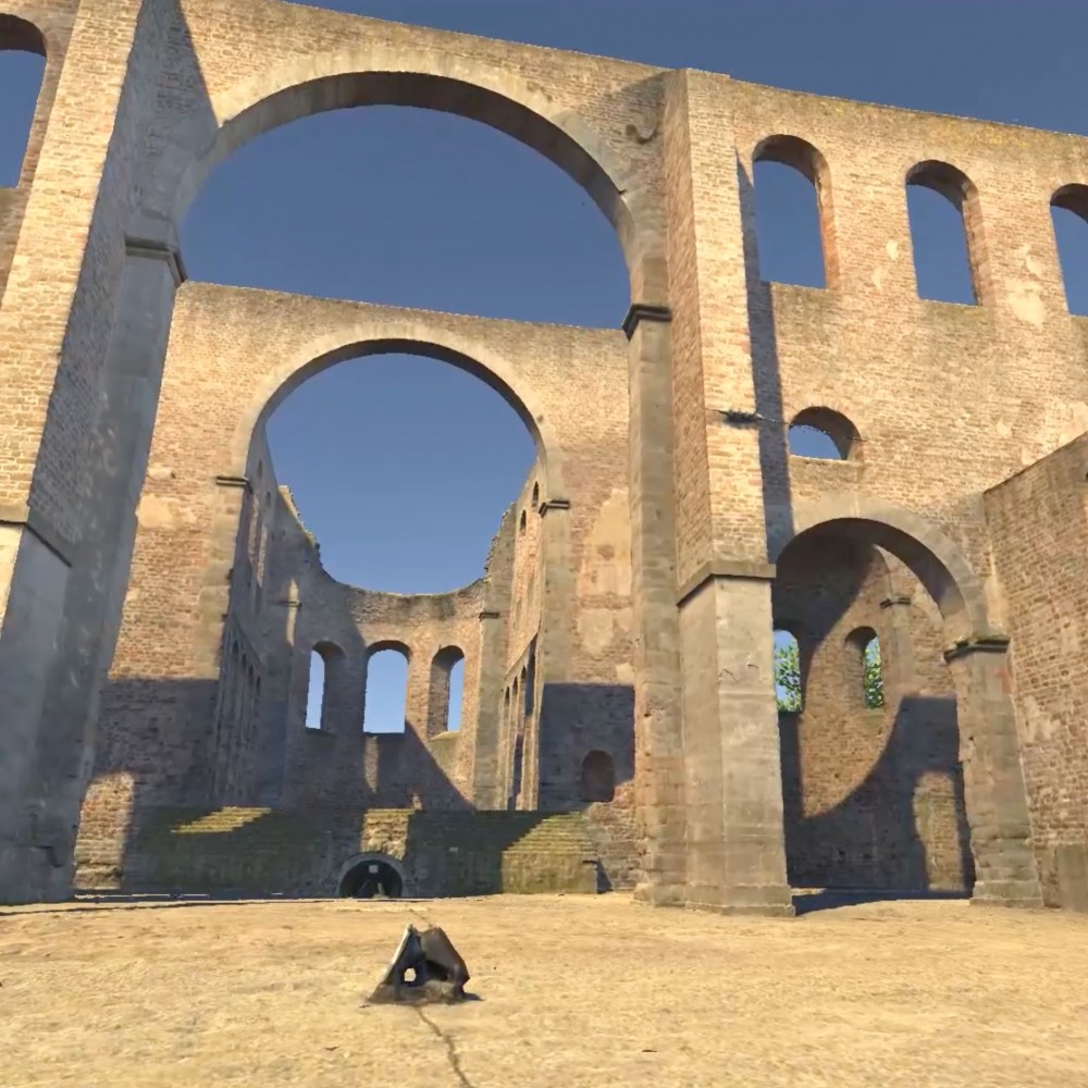
Laserscanning

Carry out a building survey remotely – capture details from your desk

Laser scanning is a modern surveying technique that creates highly accurate 3D point clouds of objects and environments. When a laser scanner is used, millions of measuring points are recorded, producing a precise digital copy of the structure to be surveyed. This technology makes it possible to capture even complex shapes and fine details, such as structural damages, in detail and to a high degree of precision.

Whether for architecture, construction projects or infrastructure analysis, laser scanning captures objects and landscapes with impressive accuracy, enabling projects to be planned and monitored without the need for physical on-site visits. 

Laser scan image of a ruin
Topotwin


advantages

  • Highly accurate measurements
    The laser scanner captures millions of data points for a detailed and accurate 3D model, precisely representing even complex structures. 
  • Efficient Analysis
    Virtual inspections and analyses using laser scanning enable fast and comprehensive assessments - independent of time and location.
  • Cost savings
    By eliminating travel costs and logistical expenses for on-site inspections, financial resources can be used more efficiently.
  • sustainable documentation
    Laser scanning simplifies the archiving and documentation of collected data, enabling smooth collaboration with project participants. 

Applications

Laser scanning provides precise data for planning, monitoring and decision making for customers in the following industries:


construction industry + architecture

CONSTRUCTION INDUSTRY AND ARCHITECTURE

Creation of as-built plans and 3D models of building sites, buildings and infrastructure for planning, monitoring and maintenance

engineering

ENGINEERING

Precise object recording for measurements for collision tests, volume and area calculations or infrastructure design and analysis

geographic information systems

GEOGRAPHIC INFORMATION SYSTEMS

Mapping and analysis of terrains and geographical data to create maps and carry out environmental analyses

monument conservation and archaeology

MONUMENT CONSERVATION AND ARCHAEOLOGY

Documentation and restoration of historical sites

real estate

REAL ESTATE

Creation of virtual tours and 3D models for marketing, sales presentations and virtual inspection

agriculture and forestry

AGRICULTURE AND FORESTRY

Mapping of forests, farmland and harvested areas to plan and monitor management measures

art + entertainment

ART AND ENTERTAINMENT

Production of 3D assets for films, video games and virtual reality by creating detailed digital models

insurance

INSURANCE

Assessment of damage and preparation of damage reports for insurance claims, especially after natural disasters or accidents

career-Topotwin

Working at Topotwin

Are you passionate about technological advancements and eager to take on exciting challenges in an innovative environment? Explore our current job openings or send us a spontaneous application – we look forward to getting to know you.

your career

Einwilligung zur Nutzung. Wir möchten die Informationen auf dieser Webseite und auch unsere Leistungsangebote auf Ihre Bedürfnisse anpassen. Zu diesem Zweck setzen wir sog. Cookies ein. Entscheiden Sie bitte selbst, welche Arten von Cookies bei der Nutzung unserer Website gesetzt werden sollen. Die Arten von Cookies, die wir einsetzen, werden in unserer Datenschutzerklärung näher beschrieben. Sie können Ihre Einwilligung später jederzeit ändern / widerrufen indem Sie in der Datenschutzerklärung entsprechende Anpassungen vornehmen. Mit Klick auf „Alles Ablehnen“ werden alle nicht notwendigen Cookies abgelehnt..